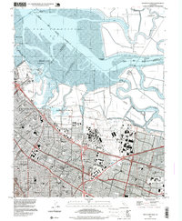
1997 Map of Mountain View
USGS Topo · Published 1999About this map
Naval Air Station Moffett Field dominates the central landscape of this late-twentieth-century study, illustrating the significant military and aerospace footprint on the San Francisco Peninsula. To the north, the sprawling Salt Evaporators and winding sloughs like Mowry Slough and Guadalupe Slough define the edge of the San Francisco Bay. This map documents a period of intense suburban and industrial development across Mountain View, Palo Alto, and Sunnyvale, where the residential grids are tightly knit between the Bayshore Freeway and the Southern Pacific railroad line. Civil infrastructure is prominently featured, from the Hetch Hetchy Aqueduct to the network of schools such as Crittenden Middle Sch and Ohlone Sch, marking the civic expansion of the Silicon Valley region before the turn of the millennium.
Find a feature on this map
48 named features on this map. Tap any name to fly to it.
Don’t see what you’re looking for? This feature index may not catch every label — zoom into the map to look around manually.
Map Details
Editions of this 1997 Mountain View Map
This is the sole edition of this map. No revisions or reprints were ever made.
Other maps of this area

1889 · San Jose
USGS Topo · 1:62,500

1897 · San Jose
USGS Topo · 1:62,500

1897 · Palo Alto
USGS Topo · 1:62,500

1899 · San Jose
USGS Topo · 1:62,500

1899 · Palo Alto
USGS Topo · 1:62,500

1899 · Haywards
USGS Topo · 1:62,500

1902 · Santa Cruz
USGS Topo · 1:125,000

1906 · Pleasanton
USGS Topo · 1:62,500

1915 · Haywards
USGS Topo · 1:62,500

1941 · Pleasanton
USGS Topo · 1:62,500