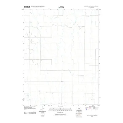
2009 Map of Mouth of Shaw Creek
USGS Topo · Published 2009About this map
The Saline River cuts a winding path across the northern reaches of this Trego County landscape, defining the local drainage system alongside its significant tributaries. This 2009 survey highlights a rural environment structured by a precise grid of section roads, where the natural hydrology of Shaw Creek and East Spring Creek dictates the few variations in the land's geometry. The infrastructure is primarily composed of local routes like Hixson Rd and Matteke Rd, which facilitate movement through the agricultural interior. For those researching local heritage, the naming of Cemetery Rd indicates a point of interest for genealogical study, while the presence of Spring Creek in the southwest corner marks another distinct watercourse in this western Kansas river valley system.
Find a feature on this map
10 named features on this map. Tap any name to fly to it.
Don’t see what you’re looking for? This feature index may not catch every label — zoom into the map to look around manually.
Map Details
Editions of this 2009 Mouth of Shaw Creek Map
This is the sole edition of this map. No revisions or reprints were ever made.
Other maps of this area

1893 · Ellis
USGS Topo · 1:125,000

1893 · Hill
USGS Topo · 1:125,000

1955 · Great Bend
USGS Topo · 1:250,000

1955 · Beloit
USGS Topo · 1:250,000

1957 · Great Bend
USGS Topo · 1:250,000

1958 · Great Bend
USGS Topo · 1:250,000

1959 · Beloit
USGS Topo · 1:250,000
1960 · Trego Center NE
USGS Topo · 1:24,000
1961 · Ogallah
USGS Topo · 1:24,000
1961 · Ellis
USGS Topo · 1:24,000