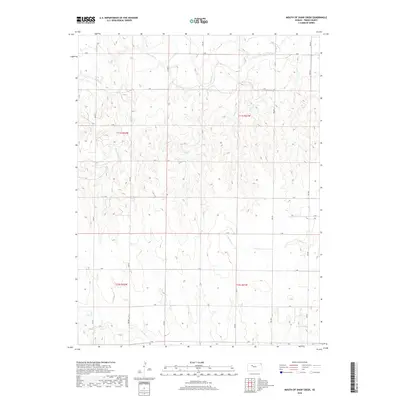
2018 Map of Mouth of Shaw Creek
USGS Topo · Published 2018About this map
The Saline River cuts across the northern reaches of this Trego County landscape, carving through the high plains of western Kansas. This 2018 survey reveals a sparse, rural environment defined by the Public Land Survey System, with the land divided into sections by a network of lettered roads including B Rd and H Rd. The drainage pattern is the dominant natural feature, as Shaw Creek and E Spring Cr feed into the regional river system. There are no named settlements or buildings indicated, showing a vast area of agricultural and open land characteristic of the Smoky Hills region. The map serves as a contemporary record of the township and range divisions, documenting the persistent grid of the Kansas prairie.
Find a feature on this map
17 named features on this map. Tap any name to fly to it.
Don’t see what you’re looking for? This feature index may not catch every label — zoom into the map to look around manually.
Map Details
Editions of this 2018 Mouth of Shaw Creek Map
This is the sole edition of this map. No revisions or reprints were ever made.
Other maps of this area

1893 · Ellis
USGS Topo · 1:125,000

1893 · Hill
USGS Topo · 1:125,000

1955 · Great Bend
USGS Topo · 1:250,000

1955 · Beloit
USGS Topo · 1:250,000

1957 · Great Bend
USGS Topo · 1:250,000

1958 · Great Bend
USGS Topo · 1:250,000

1959 · Beloit
USGS Topo · 1:250,000
1960 · Trego Center NE
USGS Topo · 1:24,000
1961 · Ogallah
USGS Topo · 1:24,000
1961 · Ellis
USGS Topo · 1:24,000