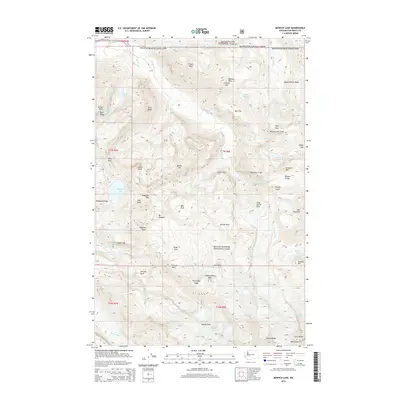
2014 Map of Mowich Lake
USGS Topo · Published 2014About this map
Mount Rainier National Park dominates this landscape, where the northern slopes of the peak descend into a complex network of glacial ice and high-altitude alpine basins. Massive ice bodies including Carbon Glacier, Russell Glacier, and Flett Glacier carve the high ridges, feeding the headwaters of the Carbon River and N Mowich River. The map illustrates the transition from the glaciated heights to lower elevation landmarks like Mowich Lake and the dramatic drop of Spray Falls. Several distinct alpine meadows, or "parks," are identified across the terrain, including Seattle Park, Mist Park, and the meadows of the Elysian Fields. This 2014 survey documents the contemporary extent of the glaciers and the established trail corridors such as Ipsut Pass and Knapsack Pass that provide access to the Snoqualmie National Forest boundary.
Find a feature on this map
81 named features on this map. Tap any name to fly to it.
Don’t see what you’re looking for? This feature index may not catch every label — zoom into the map to look around manually.
Map Details
Editions of this 2014 Mowich Lake Map
This is the sole edition of this map. No revisions or reprints were ever made.
Other maps of this area

1913 · Cedar Lake
USGS Topo · 1:125,000

1924 · Mt Rainier
USGS Topo · 1:96,000

1928 · Mt Rainier
USGS Topo · 1:125,000

1950 · Yakima
USGS Topo · 1:250,000

1956 · Greenwater
USGS Topo · 1:62,500

1956 · Enumclaw
USGS Topo · 1:62,500

1957 · Wenatchee
USGS Topo · 1:250,000

1958 · Yakima
USGS Topo · 1:250,000

1961 · Yakima
USGS Topo · 1:250,000
1971 · Sunrise
USGS Topo · 1:24,000