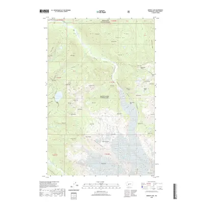
2020 Map of Mowich Lake
USGS Topo · Published 2020About this map
Mount Rainier National Park dominates this topography, where the high-altitude landscape is defined by the headwaters of the Carbon River and the N Mowich River. The northwestern section of the park is mapped here in detail, centered on the glacial waters of Mowich Lake. The trail system is a primary human feature, specifically the celebrated Wonderland trail and the Northern Loop, which connect the park’s many waterfalls and meadows. From Ranger Falls to Spray Falls, the map traces the drainage patterns from the glaciers down through heavily ridged terrain. Distinctive landmarks like Hessong Rock, Eagle Cliff, and Arthur Peak provide orientation for those navigating the high country. In the northern reaches, the boundary of the Snoqualmie National Forest borders peaks like Tirzah Peak and the remote Chenuis Lakes.
Find a feature on this map
101 named features on this map. Tap any name to fly to it.
Don’t see what you’re looking for? This feature index may not catch every label — zoom into the map to look around manually.
Map Details
Editions of this 2020 Mowich Lake Map
This is the sole edition of this map. No revisions or reprints were ever made.
Other maps of this area

1913 · Cedar Lake
USGS Topo · 1:125,000

1924 · Mt Rainier
USGS Topo · 1:96,000

1928 · Mt Rainier
USGS Topo · 1:125,000

1950 · Yakima
USGS Topo · 1:250,000

1956 · Greenwater
USGS Topo · 1:62,500

1956 · Enumclaw
USGS Topo · 1:62,500

1957 · Wenatchee
USGS Topo · 1:250,000

1958 · Yakima
USGS Topo · 1:250,000

1961 · Yakima
USGS Topo · 1:250,000
1971 · Sunrise
USGS Topo · 1:24,000