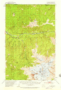
1952 Map of Mt. Baker
USGS Topo · Published 1958About this map
The massive ice-crowned peak of Mt Baker dominates this 1952 survey of Whatcom County, surrounded by a complex system of glaciers including the Coleman, Deming, and Roosevelt. Along the Nooksack River corridor, the settlement of Glacier serves as a focal point for activity, supported by the Chicago Milwaukee St Paul and Pacific railroad line. Industrial and utility footprints are visible through the Excelsior Mine and the Nooksack Power Plant, reflecting the era's reliance on mountain resources and hydroelectric potential. To the north, the terrain rises toward Church Mtn and the international border between the United States and Canada. Local history is preserved in markers such as the Cem near the river and the Excelsior Lookout, while the sprawling Mt Baker National Forest provides the backdrop for timber and recreation management evidenced by the Ranger Sta.
Find a feature on this map
85 named features on this map. Tap any name to fly to it.
Don’t see what you’re looking for? This feature index may not catch every label — zoom into the map to look around manually.
Map Details
Editions of this 1952 Mt. Baker Map
4 editions found
Other maps of this area

1909 · Mt Baker
USGS Topo · 1:192,000

1915 · Mt. Baker
USGS Topo · 1:250,000

1919 · Van Zandt
USGS Topo · 1:62,500

1921 · Wickersham
USGS Topo · 1:62,500

1951 · Wickersham
USGS Topo · 1:62,500

1951 · Van Zandt
USGS Topo · 1:62,500

1952 · Lake Shannon
USGS Topo · 1:62,500

1952 · Mt. Baker
USGS Topo · 1:62,500

1952 · Hamilton
USGS Topo · 1:62,500

1953 · Mt Shuksan
USGS Topo · 1:62,500