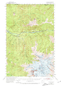
1952 Map of Mt. Baker
USGS Topo · Published 1974About this map
Mount Baker and its complex glacial systems dominate the southern portion of this 1952 field-checked study. The landscape is defined by massive ice sheets including the Coleman Glacier, Roosevelt Glacier, and Deming Glacier, which radiate from the high peaks near Grant Pk and the Summit Crater. This high-altitude terrain gives way to the deep valleys of the North Fork Nooksack River, where the settlement of Glacier serves as a hub for the Glacier Ranger Sta. Industrial footprints are evident at the Nooksack Power Plant and the Excelsior Mine, showing the reach of resource extraction and power generation into the northern wilderness. Transportation is limited to the valley floor, where the Chicago Milwaukee St Paul & Pacific railroad reaches Warnick before the terrain becomes impassable for heavy rail.
Find a feature on this map
95 named features on this map. Tap any name to fly to it.
Don’t see what you’re looking for? This feature index may not catch every label — zoom into the map to look around manually.
Map Details
Editions of this 1952 Mt. Baker Map
4 editions found
Other maps of this area

1909 · Mt Baker
USGS Topo · 1:192,000

1915 · Mt. Baker
USGS Topo · 1:250,000

1919 · Van Zandt
USGS Topo · 1:62,500

1921 · Wickersham
USGS Topo · 1:62,500

1951 · Wickersham
USGS Topo · 1:62,500

1951 · Van Zandt
USGS Topo · 1:62,500

1952 · Lake Shannon
USGS Topo · 1:62,500

1952 · Mt. Baker
USGS Topo · 1:62,500

1952 · Hamilton
USGS Topo · 1:62,500

1953 · Mt Shuksan
USGS Topo · 1:62,500