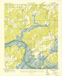
1936 Map of Mt Carmel
USGS Topo · Published 1936About this map
Guntersville Reservoir and its proposed shorelines dominate this 1936 survey, showing the landscape as it transitioned under the Tennessee Valley Authority. The map documents a riverside economy on the verge of change, where the N C and St L RR Ferry and the George S Houston Toll Bridge provide vital crossings over the Tennessee River. Away from the water, the terrain is defined by prominent ridges like Gunter Mountain and Lewis Mountain, sheltering small communities and rural institutions.
Find a feature on this map
45 named features on this map. Tap any name to fly to it.
Don’t see what you’re looking for? This feature index may not catch every label — zoom into the map to look around manually.
Map Details
Editions of this 1936 Mt Carmel Map
This is the sole edition of this map. No revisions or reprints were ever made.
Other maps of this area

1885 · Gadsden
USGS Topo · 1:125,000

1888 · Gadsden
USGS Topo · 1:125,000

1888 · Scottsboro
USGS Topo · 1:125,000

1892 · Scottsboro
USGS Topo · 1:125,000

1892 · Gadsden
USGS Topo · 1:125,000

1895 · Gadsden
USGS Topo · 1:125,000

1903 · Gadsden
USGS Topo · 1:125,000

1936 · Guntersville
USGS Topo · 1:24,000

1936 · Columbus City
USGS Topo · 1:24,000

1936 · New Hope
USGS Topo · 1:24,000