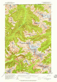
1953 Map of Mt Challenger
USGS Topo · Published 1958About this map
Mt Baker National Forest contains some of the most isolated alpine terrain in the North Cascades, dominated by the massive Challenger Glacier and the jagged summit of Mt Challenger. This 1953 field check documents a high-altitude wilderness along the border of British Columbia and Canada, where human presence is recorded only by a network of remote waypoints. Shelters such as the Little Chilliwack Shelter, Indian Creek Shelter, and Stillwell Shelter provided essential refuge for early Forest Service rangers and backcountry travelers navigating the steep drainage basins of the Chilliwack River and Little Beaver Creek.
Find a feature on this map
73 named features on this map. Tap any name to fly to it.
Don’t see what you’re looking for? This feature index may not catch every label — zoom into the map to look around manually.
Map Details
Editions of this 1953 Mt Challenger Map
4 editions found
Other maps of this area

1909 · Mt Baker
USGS Topo · 1:192,000

1915 · Mt. Baker
USGS Topo · 1:250,000

1952 · Lake Shannon
USGS Topo · 1:62,500

1953 · Mt Shuksan
USGS Topo · 1:62,500

1953 · Marblemount
USGS Topo · 1:62,500

1953 · Mt Challenger
USGS Topo · 1:62,500

1955 · Concrete
USGS Topo · 1:250,000

1958 · Concrete
USGS Topo · 1:250,000

1962 · Concrete
USGS Topo · 1:250,000

1963 · Diablo Dam
USGS Topo · 1:24,000