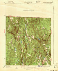
1941 Map of Mt Grace
USGS Topo · Published 1941About this map
Warwick sits at the center of this 1941 survey, showing a landscape defined by small mill ponds, timbered ridges, and New England hilltop settlements before mid-century modernization. The map documents a period of public works and conservation, featuring both Camp Warwick and a CCC Camp, reflecting the era's Civilian Conservation Corps activity. Steep terrain like Mt Grace is topped by a Fire Tower, overlooking a network of narrow roads such as Northfield Road and Winchester Road.
Find a feature on this map
66 named features on this map. Tap any name to fly to it.
Don’t see what you’re looking for? This feature index may not catch every label — zoom into the map to look around manually.
Map Details
Editions of this 1941 Mt Grace Map
2 editions found
Other maps of this area

1887 · Warwick
USGS Topo · 1:62,500

1887 · Winchendon
USGS Topo · 1:62,500

1889 · Warwick
USGS Topo · 1:62,500

1890 · Winchendon
USGS Topo · 1:62,500

1894 · Winchendon
USGS Topo · 1:62,500

1894 · Warwick
USGS Topo · 1:62,500

1898 · Monadnock
USGS Topo · 1:62,500

1898 · Keene
USGS Topo · 1:62,500

1932 · Warwick
USGS Topo · 1:48,000

1932 · Winchendon
USGS Topo · 1:48,000