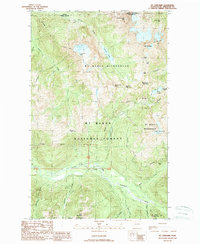
1989 Map of Mt Larrabee
USGS Topo · Published 1989About this map
The Canada United States border forms the northern limit of this high-elevation mountain terrain within the Mt Baker National Forest. Centered on the towering peak of Mt Larrabee and the sharp profile of American Border Peak, the landscape is defined by its verticality and glacial features, including Tomyhoi Lake and Twin Lakes. The area reflects a history of mineral exploration, evidenced by several high-altitude sites like the Red Mountain Mine and Gargett Mine situated near High Pass, and the Silvertip Mine located further south. In the lower elevations, the North Fork Nooksack River and Ruth Creek carve deep valleys that provide the primary access corridors through the Mt Baker Wilderness. This 1989 edition preserves the location of numerous prospects and specialized mountain infrastructure, such as the tunnel near Skagway Pass.
Find a feature on this map
40 named features on this map. Tap any name to fly to it.
Don’t see what you’re looking for? This feature index may not catch every label — zoom into the map to look around manually.
Map Details
Editions of this 1989 Mt Larrabee Map
2 editions found
Other maps of this area

1909 · Mt Baker
USGS Topo · 1:192,000

1915 · Mt. Baker
USGS Topo · 1:250,000

1952 · Mt. Baker
USGS Topo · 1:62,500

1953 · Mt Shuksan
USGS Topo · 1:62,500

1955 · Concrete
USGS Topo · 1:250,000

1958 · Concrete
USGS Topo · 1:250,000

1962 · Concrete
USGS Topo · 1:250,000

1979 · Mt. Baker
USGS Topo · 1:100,000
1989 · Shuksan Arm
USGS Topo · 1:24,000
1989 · Mt Larrabee
USGS Topo · 1:24,000