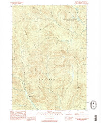
1989 Map of Mt. Pisgah
USGS Topo · Published 1989About this map
The remote forestlands of northern New Hampshire are defined by the convergence of the Dead Diamond River and the Swift Diamond River within the Dix'S Grant and Atkinson And Gilmanton Academy Grant. The 1980s landscape is primarily high-elevation terrain, anchored by the prominent Mount Pisgah and the long spine of Crystal Mountain. Human activity is sparse in this timber-rich region, marked most notably by the Swift Diamond Farm and scattered Gravel Pits used for road maintenance. This era of the New Hampshire woods shows a network of logging roads and trails winding through valleys like those of Tracy Brook and Fourmile Brook. The map reveals the intricate drainage patterns of the upper Diamond watershed, including the Little West Branch and the South Branch, providing a clear look at the watershed before modern shifts in land management.
Find a feature on this map
27 named features on this map. Tap any name to fly to it.
Don’t see what you’re looking for? This feature index may not catch every label — zoom into the map to look around manually.
Map Details
Editions of this 1989 Mt. Pisgah Map
2 editions found
Other maps of this area

1925 · Indian Stream
USGS Topo · 1:48,000

1926 · Indian Stream
USGS Topo · 1:62,500

1927 · Indian Stream
USGS Topo · 1:62,500

1927 · Second Lake
USGS Topo · 1:62,500

1930 · Dixville
USGS Topo · 1:62,500

1930 · Errol
USGS Topo · 1:62,500

1932 · Second Lake
USGS Topo · 1:62,500

1933 · Dixville
USGS Topo · 1:62,500

1934 · Dixville
USGS Topo · 1:62,500

1934 · Errol
USGS Topo · 1:62,500
Featured Places
- Clarksville, NH
- Dixville, NH
- Atkinson and Gilmanton Academy Grant, NH
- Second College Grant, NH
- Dix's Grant, NH