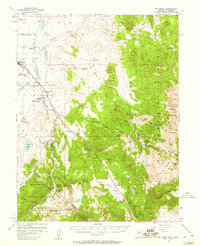
1957 Map of Mt. Siegel
USGS Topo · Published 1959About this map
Pine Nut Mountains dominate the eastern landscape of this 1957 survey, where high peaks like Mt Siegel and Galena Peak overlook a terrain marked by early Nevada mining and ranching. The East Fork Carson River winds through the valley, supporting settlements such as Gardnerville and the Indian community of Dresslerville. Historical transit points like Twelvemile House and Youngs Crossing illustrate the area's role as a corridor between the high desert and the mountains.
Find a feature on this map
66 named features on this map. Tap any name to fly to it.
Don’t see what you’re looking for? This feature index may not catch every label — zoom into the map to look around manually.
Map Details
Editions of this 1957 Mt. Siegel Map
3 editions found
Other maps of this area

1889 · Markleeville
USGS Topo · 1:125,000

1891 · Carson
USGS Topo · 1:125,000

1891 · Markleeville
USGS Topo · 1:125,000

1891 · Wabuska
USGS Topo · 1:125,000

1891 · Wellington
USGS Topo · 1:125,000

1893 · Carson
USGS Topo · 1:125,000

1893 · Markleeville
USGS Topo · 1:125,000

1893 · Wellington
USGS Topo · 1:125,000

1894 · Wabuska
USGS Topo · 1:125,000

1948 · Walker Lake
USGS Topo · 1:250,000