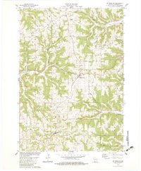
1983 Map of Mt. Sterling
USGS Topo · Published 1983About this map
Mickelson Ridge and Boma Ridge define the high terrain of Crawford County, where the dendritic drainage of Copper Creek and its branches carve deep valleys into the landscape. This 1983 revision reveals the rural character of southwestern Wisconsin, centered on the village of Mt Sterling and the community of Seneca. The map serves as a vital record for genealogists, preserving the locations of numerous family-named landmarks and local burial grounds like Eitsert Cem, Pioneer Cem, and Evergreen Cem. Settlement patterns remain tied to the ridge tops and valley floors, with traditional country churches such as Utica Ch and St Patricks Ch acting as anchors for the surrounding townships of Freeman, Utica, and Seneca. Several quarries point to local extractive activity amidst the agricultural fields and wooded hollows.
Find a feature on this map
42 named features on this map. Tap any name to fly to it.
Don’t see what you’re looking for? This feature index may not catch every label — zoom into the map to look around manually.
Map Details
Editions of this 1983 Mt. Sterling Map
This is the sole edition of this map. No revisions or reprints were ever made.
Other maps of this area

1903 · Waukon
USGS Topo · 1:125,000

1924 · Gays Mills
USGS Topo · 1:62,500

1926 · Gays Mills
USGS Topo · 1:62,500

1926 · Wauzeka
USGS Topo · 1:62,500

1929 · Ferryville
USGS Topo · 1:62,500

1929 · Prairie Du Chien
USGS Topo · 1:62,500

1932 · Ferryville
USGS Topo · 1:62,500

1932 · Prairie Du Chien
USGS Topo · 1:62,500

1958 · La Crosse
USGS Topo · 1:250,000

1961 · La Crosse
USGS Topo · 1:250,000