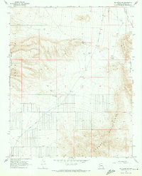
1968 Map of Mt. Tipton NW
USGS Topo · Published 1971About this map
The high desert landscape of Mohave County is defined here by the meeting of the Cerbat Mountains and the northern reach of the White Hills. This 1968 survey details a region where water management was the primary infrastructure of the range, evidenced by numerous named catchment points such as Miller Tank, Filaree Tank, and Black Mesa Tank. The map shows a transition from high plateau terrain to the broad Hualapai Valley, with ranching history etched into the land at sites like Archibald Corral. Transportation through this arid corridor relied on established routes like Pierce Ferry Road and Stockton Hill Road, which provided essential links across the desert floor toward the distant Colorado River crossings.
Find a feature on this map
18 named features on this map. Tap any name to fly to it.
Don’t see what you’re looking for? This feature index may not catch every label — zoom into the map to look around manually.
Map Details
Editions of this 1968 Mt. Tipton NW Map
2 editions found
Other maps of this area

1886 · Camp Mohave
USGS Topo · 1:250,000

1892 · Camp Mohave
USGS Topo · 1:250,000

1942 · Camp Mohave
USGS Topo · 1:250,000

1947 · Kingman
USGS Topo · 1:250,000

1948 · Kingman
USGS Topo · 1:250,000

1954 · Kingman
USGS Topo · 1:250,000

1955 · Kingman
USGS Topo · 1:250,000

1958 · Kingman
USGS Topo · 1:250,000

1960 · Kingman
USGS Topo · 1:250,000
1960 · Senator Mountain
USGS Topo · 1:62,500