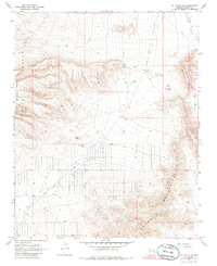
1968 Map of Mt. Tipton NW
USGS Topo · Published 1986About this map
Pierce Ferry Road cuts a long diagonal through this desert landscape, linking the high terrain of the White Hills and Table Mountain Plateau with the low-lying Hualapai Valley. This 1968 field check reveals a ranching and water-management network essential for survival in Mohave County. Ranching infrastructure is scattered across the dry basins, including the Archibald Corral and Corral WT, alongside a series of catchment features like Black Mesa Tank, Miller Tank, and Barksdale Tank. In the southeast, the rugged ascent into the Cerbat Mountains is marked by a Jeep Trail and a single Drill Hole, suggesting the early stages of mineral exploration or water surveying. The map effectively captures the isolated nature of the Arizona desert before modern expansion, where life was defined by the proximity to water tanks and the reliability of primitive roads.
Find a feature on this map
20 named features on this map. Tap any name to fly to it.
Don’t see what you’re looking for? This feature index may not catch every label — zoom into the map to look around manually.
Map Details
Editions of this 1968 Mt. Tipton NW Map
2 editions found
Other maps of this area

1886 · Camp Mohave
USGS Topo · 1:250,000

1892 · Camp Mohave
USGS Topo · 1:250,000

1942 · Camp Mohave
USGS Topo · 1:250,000

1947 · Kingman
USGS Topo · 1:250,000

1948 · Kingman
USGS Topo · 1:250,000

1954 · Kingman
USGS Topo · 1:250,000

1955 · Kingman
USGS Topo · 1:250,000

1958 · Kingman
USGS Topo · 1:250,000

1960 · Kingman
USGS Topo · 1:250,000
1960 · Senator Mountain
USGS Topo · 1:62,500