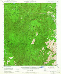
1947 Map of Mt. Union
USGS Topo · Published 1964About this map
Prescott National Forest dominates this 1940s landscape, revealing a complex network of mining claims and high-altitude settlements. The Senator Highway serves as the primary artery through the high country, connecting remote outposts like Palace Station and Venezia. Mining activity is evident throughout the terrain, with concentrated operations such as the Bannie Mine, Cash Mine, and St Theresa Mine scattered across the slopes of Mt Union and Spruce Mtn.
Find a feature on this map
90 named features on this map. Tap any name to fly to it.
Don’t see what you’re looking for? This feature index may not catch every label — zoom into the map to look around manually.
Map Details
Editions of this 1947 Mt. Union Map
3 editions found

Other maps of this area

1887 · Prescott
USGS Topo · 1:250,000

1892 · Prescott
USGS Topo · 1:250,000

1903 · Bradshaw Mountains
USGS Topo · 1:125,000

1903 · Congress
USGS Topo · 1:125,000

1904 · Congress
USGS Topo · 1:125,000

1905 · Jerome
USGS Topo · 1:125,000

1944 · Mingus Mountain
USGS Topo · 1:62,500

1947 · Mingus Mtn
USGS Topo · 1:62,500

1947 · Crown King
USGS Topo · 1:62,500

1947 · Bumblebee
USGS Topo · 1:62,500