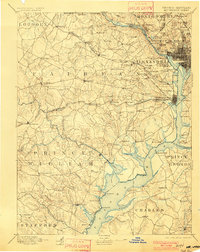
1897 Map of Mt. Vernon
USGS Topo · Published 1901About this map
The Potomac River corridor serves as the central artery for this late-19th-century landscape, anchoring a network of historic estates, defensive fortifications, and expanding rail lines. At the heart of the region, the Arlington National Cemetery and Mt Vernon overlook the river, while the military significance of the waterway is marked by Fort Foote and Fort Washington. The era's transportation infrastructure is prominently displayed, from the upstream Chain Bridge and Cabin Johns Bridge to the web of railroads including the Southern R. R. Va. Midland Div. and the B. & O. R. R..
Find a feature on this map
162 named features on this map. Tap any name to fly to it.
Don’t see what you’re looking for? This feature index may not catch every label — zoom into the map to look around manually.
Map Details
Editions of this 1897 Mt. Vernon Map
2 editions found

Other maps of this area

1884 · Harpers Ferry
USGS Topo · 1:125,000

1887 · Spottsylvania
USGS Topo · 1:125,000

1889 · Fredericksburg
USGS Topo · 1:125,000

1890 · Mt. Vernon
USGS Topo · 1:125,000

1891 · Harpers Ferry
USGS Topo · 1:125,000

1891 · Mt. Vernon
USGS Topo · 1:125,000

1892 · Laurel
USGS Topo · 1:62,500

1892 · Fredericksburg
USGS Topo · 1:125,000

1892 · Spottsylvania
USGS Topo · 1:125,000

1892 · Brandywine
USGS Topo · 1:62,500