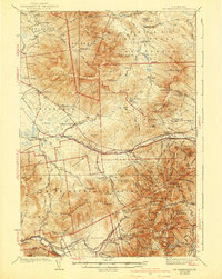
1938 Map of Mt. Washington
USGS Topo · Published 1943About this map
Mt Washington Cog RR climbs toward the peak of Mt Washington in this detailed study of the Presidential and Pliny Ranges during the late 1930s. The landscape is defined by the intersections of recreation and industry, from the luxury of Bretton Woods and the Ravine House to the utilitarian structures of Zealand Camp and Camp 18. Transportation corridors such as the Maine Central RR and the Boston and Maine RR follow the river valleys, while higher elevations are marked by the AMC Hut and the Fire Tower on Lonesome Ridge. Local civic life is captured through rural schoolhouses like Mt Cabot Sch and the Gore Sch, and the presence of the Israel River Ranger Station highlights the federal management of the Kilkenny National Forest and White Mountain National Forest.
Find a feature on this map
94 named features on this map. Tap any name to fly to it.
Don’t see what you’re looking for? This feature index may not catch every label — zoom into the map to look around manually.
Map Details
Editions of this 1938 Mt. Washington Map
4 editions found
Other maps of this area

1893 · Mt. Washington
USGS Topo · 1:62,500

1893 · Gorham
USGS Topo · 1:62,500

1894 · North Conway
USGS Topo · 1:62,500

1895 · Crawford Notch
USGS Topo · 1:62,500

1896 · Mt. Washington
USGS Topo · 1:62,500

1896 · Crawford Notch
USGS Topo · 1:62,500

1896 · North Conway
USGS Topo · 1:62,500

1896 · Gorham
USGS Topo · 1:62,500

1900 · Whitefield
USGS Topo · 1:62,500

1920 · Guildhall
USGS Topo · 1:62,500