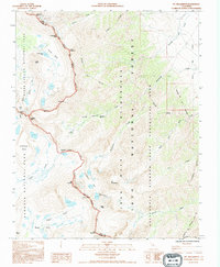
1993 Map of Mt. Williamson
USGS Topo · Published 1994About this map
Mt Williamson dominates the center of this high-altitude survey, marking a formidable point on the boundary where Inyo National Forest meets the wild upper reaches of Sequoia National Park. The landscape is a network of granite peaks and alpine basins, including the Williamson Bowl and Lake Helen of Troy. This 1993 provisional update focuses on the complex drainage systems of the Eastern Sierra, such as Shepherd Creek and Bairs Creek, which descend sharply toward the Owens Valley. High-mountain passage is documented via the John Muir Trail and the steep Shepherd Pass Trail, which reaches Shepherd Pass at the park line. Small human imprints in this wilderness environment are limited to remote sites like Anvil Camp and the Corral Gaging Station, used for monitoring the vital water runoff from the snowpack. The presence of the California Bighorn Sheep Zoological Area underscores the region's importance as a protected wildlife corridor during the late twentieth century.
Find a feature on this map
40 named features on this map. Tap any name to fly to it.
Don’t see what you’re looking for? This feature index may not catch every label — zoom into the map to look around manually.
Map Details
Editions of this 1993 Mt. Williamson Map
This is the sole edition of this map. No revisions or reprints were ever made.
Other maps of this area

1907 · Mt. Whitney
USGS Topo · 1:125,000

1919 · Mt. Whitney
USGS Topo · 1:125,000

1937 · Mt. Whitney
USGS Topo · 1:125,000

1948 · Fresno
USGS Topo · 1:250,000

1951 · Independence
USGS Topo · 1:62,500

1953 · Mt. Pinchot
USGS Topo · 1:62,500

1955 · Fresno
USGS Topo · 1:250,000

1956 · Fresno
USGS Topo · 1:250,000

1956 · Mount Whitney
USGS Topo · 1:62,500

1958 · Fresno
USGS Topo · 1:250,000