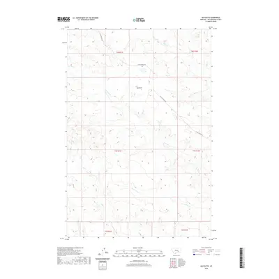
2020 Map of Mud Butte
USGS Topo · Published 2020About this map
Mud Butte rises as a prominent landmark in this high-plains landscape of Yellowstone County, where the topography is defined by the erosion patterns of several intermittent drainages. The map reveals a network of watercourses including Buffalo Cr and Antelope Cr to the north, while the southern reaches are shaped by the winding paths of Mill Cr and Dry Antelope Cr. The absence of dense town sites highlights the area's grazing and ranching character, centered around the solitary thoroughfare of Custer Pineview Rd. This survey details the township and range lines across a series of sections including t5n r31e and t6n r32e, showing the structured land division that governs this vast Montana rangeland.
Find a feature on this map
12 named features on this map. Tap any name to fly to it.
Don’t see what you’re looking for? This feature index may not catch every label — zoom into the map to look around manually.
Map Details
Editions of this 2020 Mud Butte Map
This is the sole edition of this map. No revisions or reprints were ever made.
Other maps of this area

1954 · Forsyth
USGS Topo · 1:250,000

1957 · Forsyth
USGS Topo · 1:250,000

1958 · Forsyth
USGS Topo · 1:250,000

1960 · Coal Bank Creek
USGS Topo · 1:24,000

1960 · Waco
USGS Topo · 1:24,000
1967 · Big Marys Island
USGS Topo · 1:24,000
1967 · Bull Mountain
USGS Topo · 1:24,000

1979 · Hysham
USGS Topo · 1:100,000

1980 · Mud Butte
USGS Topo · 1:24,000
1980 · Bull Mountain NW
USGS Topo · 1:24,000