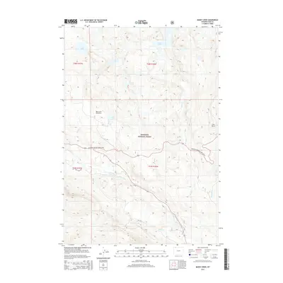
2015 Map of Muddy Creek
USGS Topo · Published 2015About this map
Shoshone National Forest lands dominate this high-elevation landscape, where the Beartooth Mountains define the topography north of the Clarks Fork Yellowstone River. The drainage network is complex, characterized by numerous alpine water bodies including Lake Reno, Lost Lake, and Granite Lake in the northern reaches, while Lily Lake sits further south near the intersection of Lake Cr and Gilbert Cr. Transportation through this wilderness is centered on the Beartooth National Scenic Byway, which winds across the central portion of the quadrangle. Local routes such as Bar F Ranch Rd and Rd Xux provide access to the more remote southern sections near Squaw Cr and Blacktail Cr. To the east, the prominent elevation of Clay Butte stands near the confluence of Ghost Cr and Muddy Cr.
Find a feature on this map
22 named features on this map. Tap any name to fly to it.
Don’t see what you’re looking for? This feature index may not catch every label — zoom into the map to look around manually.
Map Details
Editions of this 2015 Muddy Creek Map
This is the sole edition of this map. No revisions or reprints were ever made.
Other maps of this area

1896 · Crandall Creek
USGS Topo · 1:125,000

1898 · Granite Mountain District
USGS Topo · 1:125,000

1899 · Crandall
USGS Topo · 1:125,000

1954 · Billings
USGS Topo · 1:250,000

1955 · Cody
USGS Topo · 1:250,000

1956 · Alpine
USGS Topo · 1:62,500

1956 · Beartooth Butte
USGS Topo · 1:62,500

1956 · Cooke City
USGS Topo · 1:62,500

1956 · Pilot Peak
USGS Topo · 1:62,500

1957 · Billings
USGS Topo · 1:250,000