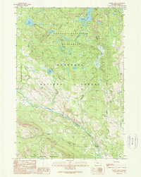
1989 Map of Muddy Creek
USGS Topo · Published 1989About this map
Clarks Fork Yellowstone River carves a deep path through this 1989 provisional survey, defining the transition between the Shoshone National Forest and the high elevations of the Absaroka-Beartooth Wilderness. The landscape is dominated by glacial-cut terrain and numerous alpine water bodies such as Granite Lake and Lake Reno. The map illustrates a primitive transportation network, where trails and light-duty roads serve isolated points of interest like the Maintenance Station near Muddy Creek and the notable overlook at Clay Butte. To the south, the boundary of the North Absaroka Wilderness encloses the lower reaches of Squaw Creek and the prominent Hunter Peak. This record captures the region just as it appeared in the late 1980s, preserving the exact layout of wilderness boundaries and backcountry access routes.
Find a feature on this map
16 named features on this map. Tap any name to fly to it.
Don’t see what you’re looking for? This feature index may not catch every label — zoom into the map to look around manually.
Map Details
Editions of this 1989 Muddy Creek Map
This is the sole edition of this map. No revisions or reprints were ever made.
Other maps of this area

1896 · Crandall Creek
USGS Topo · 1:125,000

1898 · Granite Mountain District
USGS Topo · 1:125,000

1899 · Crandall
USGS Topo · 1:125,000

1954 · Billings
USGS Topo · 1:250,000

1955 · Cody
USGS Topo · 1:250,000

1956 · Alpine
USGS Topo · 1:62,500

1956 · Beartooth Butte
USGS Topo · 1:62,500

1956 · Cooke City
USGS Topo · 1:62,500

1956 · Pilot Peak
USGS Topo · 1:62,500

1957 · Billings
USGS Topo · 1:250,000