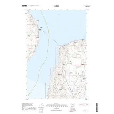
2020 Map of Mukilteo
USGS Topo · Published 2020About this map
Possession Sound separates the southern tip of Whidbey Island from the mainland industrial and aviation hubs of Snohomish County. The vital maritime connection of the Mukilteo - Clinton Ferry bridges the gap between the rural residential character of Clinton and the developed waterfront of Mukilteo. On the mainland, the sprawling infrastructure of the Snohomish County Airport (Paine Field) dominates the interior landscape, surrounded by residential enclaves like Harbour Pointe and Nelsons Corner. The map preserves local history through the siting of the Mukilteo Pioneer Cem near Elliot Point and the Clinton Cem on the island side. Coastal drainage is marked by features like the Powder Mill Gulch Retention Basin, while the eastern edge of the sheet transitions into the suburban reaches of Everett and Fairmont.
Find a feature on this map
121 named features on this map. Tap any name to fly to it.
Don’t see what you’re looking for? This feature index may not catch every label — zoom into the map to look around manually.
Map Details
Editions of this 2020 Mukilteo Map
This is the sole edition of this map. No revisions or reprints were ever made.
Other maps of this area

1895 · Snohomish
USGS Topo · 1:125,000

1897 · Seattle
USGS Topo · 1:125,000

1911 · Mount Vernon
USGS Topo · 1:125,000

1941 · Marysville
USGS Topo · 1:62,500

1942 · Edmonds
USGS Topo · 1:62,500

1943 · Marysville
USGS Topo · 1:62,500

1943 · Stanwood
USGS Topo · 1:62,500

1944 · Everett
USGS Topo · 1:62,500
1953 · Edmonds West
USGS Topo · 1:24,000
1953 · Bothell
USGS Topo · 1:24,000