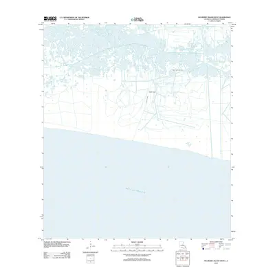
2012 Map of Mulberry Island West
USGS Topo · Published 2012About this map
Pecan Island Gas Field stands as the primary industrial feature in this coastal reach of Vermilion Parish, where the low-lying marshland meets the open waters of the Gulf of Mexico. The landscape is defined by an intricate network of narrow waterways and access routes carved through the wetlands, supporting the region's energy extraction infrastructure. Central to the local hydrography is the Dewitt Canal, which cuts through the terrain to facilitate drainage and navigation. This 2012 survey illustrates the characteristic coastal Louisiana geography where industrial utility and natural tidal environments converge, providing a clear record of the man-made modifications required to manage and harvest resources from this specialized environment.
Find a feature on this map
3 named features on this map. Tap any name to fly to it.
Don’t see what you’re looking for? This feature index may not catch every label — zoom into the map to look around manually.
Map Details
Editions of this 2012 Mulberry Island West Map
This is the sole edition of this map. No revisions or reprints were ever made.
Other maps of this area

1932 · Constance Bayou NE
USGS Topo · 1:31,680

1932 · Pecan Island SE
USGS Topo · 1:31,680

1932 · Pecan Island SW
USGS Topo · 1:31,680

1932 · Constance Bayou SE
USGS Topo · 1:31,680

1945 · Pecan Island NW
USGS Topo · 1:31,680

1945 · Pecan Island NE
USGS Topo · 1:31,680

1951 · Pecan Island
USGS Topo · 1:62,500
1954 · Constance Bayou SE
USGS Topo · 1:31,680
1954 · Pecan Island SW
USGS Topo · 1:31,680
1954 · Pecan Island NE
USGS Topo · 1:31,680