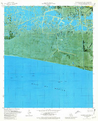
1979 Map of Mulberry Island West
USGS Topo · Published 1980About this map
The salt marshes and coastal ridges of Vermilion Parish are captured here during a period of significant energy infrastructure development. Pecan Island dominates the northern landscape, characterized by its distinct chenier ridges that provide rare high ground amidst the surrounding wetlands. Further south, the map transitions into the coastal waters of the Gulf of Mexico, where the coastline is marked by Mulberry Island and several water control structures like a dam.
Find a feature on this map
13 named features on this map. Tap any name to fly to it.
Don’t see what you’re looking for? This feature index may not catch every label — zoom into the map to look around manually.
Map Details
Editions of this 1979 Mulberry Island West Map
This is the sole edition of this map. No revisions or reprints were ever made.
Other maps of this area

1932 · Constance Bayou NE
USGS Topo · 1:31,680

1932 · Pecan Island SE
USGS Topo · 1:31,680

1932 · Pecan Island SW
USGS Topo · 1:31,680

1932 · Constance Bayou SE
USGS Topo · 1:31,680

1945 · Pecan Island NW
USGS Topo · 1:31,680

1945 · Pecan Island NE
USGS Topo · 1:31,680

1951 · Pecan Island
USGS Topo · 1:62,500
1954 · Constance Bayou SE
USGS Topo · 1:31,680
1954 · Pecan Island SW
USGS Topo · 1:31,680
1954 · Pecan Island NE
USGS Topo · 1:31,680