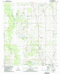
1987 Map of Muldon
USGS Topo · Published 1987About this map
Industrial utility and rural life intersect along the Monroe Co Clay Co line, where the landscape is defined by extensive energy infrastructure. The northern portion of the sheet is dominated by the Muldon Gas Storage Field, supported by a Compressor Station and a network of pipelines. Further south, the West Point Gas Field and a dedicated Fish Hatchery near a massive Levee system highlight the varied land use in the late 1980s.
Find a feature on this map
34 named features on this map. Tap any name to fly to it.
Don’t see what you’re looking for? This feature index may not catch every label — zoom into the map to look around manually.
Map Details
Editions of this 1987 Muldon Map
This is the sole edition of this map. No revisions or reprints were ever made.
Other maps of this area

1953 · West Point
USGS Topo · 1:250,000

1958 · West Point
USGS Topo · 1:250,000

1959 · West Point
USGS Topo · 1:62,500

1959 · Van Vleet
USGS Topo · 1:62,500

1959 · Pheba
USGS Topo · 1:62,500

1963 · West Point
USGS Topo · 1:250,000

1966 · Aberdeen
USGS Topo · 1:24,000

1966 · Prairie
USGS Topo · 1:24,000

1982 · West Point
USGS Topo · 1:100,000

1984 · West Point
USGS Topo · 1:250,000