
1970 Map of Muldrow SW
USGS Topo · Published 1970About this map
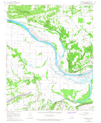
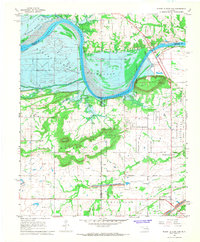
The Arkansas River carves a sweeping path through this Le Flore County landscape, defining the agricultural and topographical character of the region. This 1970s orthophoto survey reveals the intricate relationship between the waterway and the surrounding flatlands, where the river's historic shifts have left distinct patterns in the soil. Smaller tributaries like Onion Creek and Cache Creek meander through the southern and eastern portions of the quadrangle, feeding into the larger river system. Small settlements and crossroads such as Tucker, Foreman, and Redland are visible as clusters of development amidst a grid of rural fields. Near the southern edge, the high ground of Stony Point overlooks the low-lying basin, providing a clear view of the land-use patterns and property divisions that shaped this part of Oklahoma during the late twentieth century.
Find a feature on this map
7 named features on this map. Tap any name to fly to it.
Don’t see what you’re looking for? This feature index may not catch every label — zoom into the map to look around manually.
Map Details
Editions of this 1970 Muldrow SW Map
This is the sole edition of this map. No revisions or reprints were ever made.
Other maps of this area

1900 · Sallisaw
USGS Topo · 1:125,000

1911 · Sallisaw
USGS Topo · 1:125,000

1946 · Fort Smith
USGS Topo · 1:250,000

1965 · Fort Smith
USGS Topo · 1:250,000
1966 · Muldrow
USGS Topo · 1:24,000
1966 · Gans
USGS Topo · 1:24,000
1966 · Muldrow SW
USGS Topo · 1:24,000

1967 · Fort Smith
USGS Topo · 1:250,000
1967 · Sallisaw
USGS Topo · 1:24,000
1967 · Robert S Kerr Dam
USGS Topo · 1:24,000