
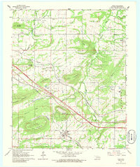
1966 Map of Gans
USGS Topo · Published 1967About this map
Gans and the surrounding township of Hanson are defined by a complex network of ridges and mountains that constrained early Oklahoma development to the narrow valley floors. Two major rail lines, the Kansas City Southern and the Missouri Pacific, cut diagonally across the terrain, serving the small communities of Seven Oaks and Blackjack. Numerous family and community burial grounds, such as Seabolt Cem, Mitchell Cem, and Ross Cem, are tucked away along the base of features like Hanson Mountain and Baldridge Mountain. The landscape is dotted with rural institutions including Prices Chapel and Central High Sch, reflecting the community structure of Sequoyah County before later modernization altered the local road patterns.
Find a feature on this map
58 named features on this map. Tap any name to fly to it.
Don’t see what you’re looking for? This feature index may not catch every label — zoom into the map to look around manually.
Map Details
Editions of this 1966 Gans Map
2 editions found
Other maps of this area

1898 · Tahlequah
USGS Topo · 1:125,000

1900 · Sallisaw
USGS Topo · 1:125,000

1901 · Tahlequah
USGS Topo · 1:125,000

1905 · Tahlequah
USGS Topo · 1:125,000

1911 · Sallisaw
USGS Topo · 1:125,000

1946 · Fort Smith
USGS Topo · 1:250,000

1965 · Fort Smith
USGS Topo · 1:250,000
1966 · Muldrow
USGS Topo · 1:24,000

1966 · Muldrow SW
USGS Topo · 1:24,000

1967 · Fort Smith
USGS Topo · 1:250,000