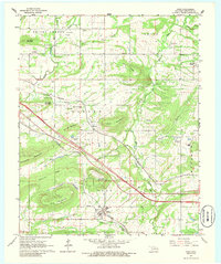
1966 Map of Gans
USGS Topo · Published 1986About this map
Gans and Hanson serve as the primary hubs of this Sequoyah County landscape, where the Kansas City Southern and Missouri Pacific railroads converge to shape the local economy during the mid-1960s. The map reveals a dense network of family and community history, evidenced by numerous burial grounds like Peters Cem and Faulkner Cem, alongside rural social centers such as Prices Chapel and Blackjack Chapel. The terrain is defined by prominent elevations including Wildhorse Mountain and Pine Mountain, which rise above the drainages of Skin Bayou and Wolf Creek. Small settlements like Seven Oaks and Maple are connected by a web of county roads, while the presence of Gas Wells near the southern edge of the survey points to the area's diversifying natural resource development.
Find a feature on this map
56 named features on this map. Tap any name to fly to it.
Don’t see what you’re looking for? This feature index may not catch every label — zoom into the map to look around manually.
Map Details
Editions of this 1966 Gans Map
2 editions found
Other maps of this area

1898 · Tahlequah
USGS Topo · 1:125,000

1900 · Sallisaw
USGS Topo · 1:125,000

1901 · Tahlequah
USGS Topo · 1:125,000

1905 · Tahlequah
USGS Topo · 1:125,000

1911 · Sallisaw
USGS Topo · 1:125,000

1946 · Fort Smith
USGS Topo · 1:250,000

1965 · Fort Smith
USGS Topo · 1:250,000
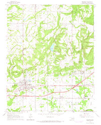
1966 · Muldrow
USGS Topo · 1:24,000

1966 · Gans
USGS Topo · 1:24,000

1966 · Muldrow SW
USGS Topo · 1:24,000