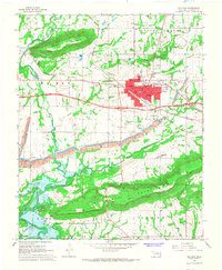
1967 Map of Sallisaw
USGS Topo · Published 1968About this map
Sallisaw serves as the focal point of this 1960s survey, showing a landscape defined by the intersection of major rail lines and industrial activity. The Missouri Pacific and Kansas City Southern railroads cross through the heart of the community, supporting the nearby Strip Mines and local Gravel Pit. To the south, the recently established Robert S. Kerr Reservoir has altered the course of Sallisaw Creek, creating a new shoreline near the settlement of Sadie. This era reflects a transition toward modern infrastructure, evidenced by the Sallisaw Municipal Airport and a Drive-in Theater, even as rural landmarks like Badger Lee Ch and Buffington Cem preserve older family and community ties. The terrain is dramatically shaped by Badger Mountain in the north and Wildhorse Mountain to the south, framing the valley's development.
Find a feature on this map
44 named features on this map. Tap any name to fly to it.
Don’t see what you’re looking for? This feature index may not catch every label — zoom into the map to look around manually.
Map Details
Editions of this 1967 Sallisaw Map
3 editions found
Other maps of this area

1898 · Tahlequah
USGS Topo · 1:125,000

1900 · Sallisaw
USGS Topo · 1:125,000

1901 · Tahlequah
USGS Topo · 1:125,000

1905 · Tahlequah
USGS Topo · 1:125,000

1911 · Sallisaw
USGS Topo · 1:125,000

1946 · Fort Smith
USGS Topo · 1:250,000

1965 · Fort Smith
USGS Topo · 1:250,000

1966 · Gans
USGS Topo · 1:24,000

1966 · Muldrow SW
USGS Topo · 1:24,000

1967 · Fort Smith
USGS Topo · 1:250,000