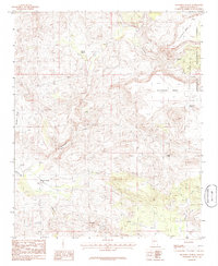
1986 Map of Muleshoe Ranch
USGS Topo · Published 1986About this map
Muleshoe Ranch sits at the heart of this Yavapai County landscape, where the confluence of several drainages meets the Santa Maria River. The terrain is defined by high tablelands, including Sycamore Mesa, Buckhorn Mesa, and Hackberry Mesa, which overlook a network of seasonal water sources like Loco Creek and Buckhorn Tanks. A portion of the Prescott National Forest occupies the northeast corner, showing the boundary between managed timberland and the more arid ranching country to the west.
Find a feature on this map
20 named features on this map. Tap any name to fly to it.
Don’t see what you’re looking for? This feature index may not catch every label — zoom into the map to look around manually.
Map Details
Editions of this 1986 Muleshoe Ranch Map
This is the sole edition of this map. No revisions or reprints were ever made.
Other maps of this area

1887 · Prescott
USGS Topo · 1:250,000

1892 · Prescott
USGS Topo · 1:250,000

1903 · Congress
USGS Topo · 1:125,000

1904 · Congress
USGS Topo · 1:125,000

1923 · Signal
USGS Topo · 1:250,000

1942 · Signal
USGS Topo · 1:250,000

1945 · Bagdad
USGS Topo · 1:62,500

1947 · Sheridan Mountain
USGS Topo · 1:62,500

1948 · Sheridan Mountain
USGS Topo · 1:63,360

1948 · Bagdad
USGS Topo · 1:62,500