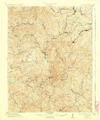
1912 Map of Mullens
USGS Topo · Published 1925About this map
The Virginian RR serves as the industrial spine of this coal-country survey, winding through the narrow valleys and across high ridges to connect mountain settlements. At the heart of the terrain, Mullens and Elmore sit at the confluence of the Slab Fork and the Guyandot River, functioning as vital rail hubs for the surrounding mining operations. The map documents the rapid development of early twentieth-century company towns such as Stotesbury, Tams, and Glen White, each tucked into steep hollows where the railroad tracks meet the mine mouths.
Find a feature on this map
72 named features on this map. Tap any name to fly to it.
Don’t see what you’re looking for? This feature index may not catch every label — zoom into the map to look around manually.
Map Details
Editions of this 1912 Mullens Map
2 editions found

Other maps of this area

1887 · Pocahontas
USGS Topo · 1:125,000

1891 · Tazewell
USGS Topo · 1:125,000

1891 · Pocahontas
USGS Topo · 1:125,000

1891 · Oceana
USGS Topo · 1:125,000

1891 · Raleigh
USGS Topo · 1:125,000

1893 · Oceana
USGS Topo · 1:125,000

1894 · Pocahontas
USGS Topo · 1:125,000

1895 · Tazewell
USGS Topo · 1:125,000

1895 · Pocahontas
USGS Topo · 1:125,000

1897 · Tazewell
USGS Topo · 1:125,000