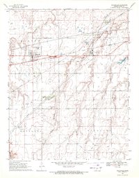
1969 Map of Mullinville
USGS Topo · Published 1971About this map
Mullinville stands at the center of this Kiowa County landscape, defined by its role as a regional transit hub in the late 1960s. The Chicago Rock Island and Pacific railroad bisects the terrain, running parallel to highway 54 and connecting the main town site to the smaller settlement at Joy. The infrastructure of the era is clearly visible, from the Sewage Disposal Ponds and a Fish Hatchery near the tracks to the local recreation at Washington Park and a nearby Golf Course. To the north and south, the prairie is cut by the winding course of Rattlesnake Creek and its South Branch, which provide the primary drainage for the agricultural lands of Martin, Garfield, Westland, and Highland townships. Local landmarks such as Hillcrest Cem and the waters of Cossell Lake provide specific points of interest for those tracing family history or the development of this Great Plains community.
Find a feature on this map
19 named features on this map. Tap any name to fly to it.
Don’t see what you’re looking for? This feature index may not catch every label — zoom into the map to look around manually.
Map Details
Editions of this 1969 Mullinville Map
This is the sole edition of this map. No revisions or reprints were ever made.
Other maps of this area

1889 · Kinsley
USGS Topo · 1:125,000

1892 · Kinsley
USGS Topo · 1:125,000

1892 · Spearville
USGS Topo · 1:125,000

1892 · Coldwater
USGS Topo · 1:125,000

1894 · Spearville
USGS Topo · 1:125,000

1894 · Kinsley
USGS Topo · 1:125,000

1896 · Ashland
USGS Topo · 1:125,000

1955 · Pratt
USGS Topo · 1:250,000

1959 · Pratt
USGS Topo · 1:250,000

1969 · Bucklin NE
USGS Topo · 1:24,000