
1953 Map of Munuscong
USGS Topo · Published 1955About this map
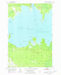
Munuscong Lake and the intricate shoreline of the St. Marys River system dominate this 1950s survey of the Upper Peninsula’s eastern edge. The small settlement of Munuscong sits at the northern end of the lake, adjacent to the vital navigation route of the West Neebish Channel. This waterway separates the mainland from the western shores of Neebish Island, marked by several navigational aids including the Pilot Island Light. The southern half of the map transition into the expansive Munuscong State Forest, where the Gogomain River and its West Branch snake through the GOGOMAIN SWAMP before emptying into the bay. Significant topographical detail is captured along the shoreline points, such as Winter Point, Roach Point, and Sawmill Point, illustrating a landscape shaped by water and timber resources during the mid-century era.
Find a feature on this map
25 named features on this map. Tap any name to fly to it.
Don’t see what you’re looking for? This feature index may not catch every label — zoom into the map to look around manually.
Map Details
Editions of this 1953 Munuscong Map
2 editions found
Other maps of this area

1913 · Sault Sainte Marie
USGS Topo · 1:62,500

1919 · Neebish
USGS Topo · 1:62,500

1931 · Pickford SE
USGS Topo · 1:31,680

1941 · Neebish
USGS Topo · 1:63,360

1941 · Sault Sainte Marie
USGS Topo · 1:63,360

1951 · Barbeau
USGS Topo · 1:24,000

1951 · Oak Ridge
USGS Topo · 1:24,000

1951 · Sault Ste. Marie
USGS Topo · 1:62,500

1951 · Lake George
USGS Topo · 1:62,500

1953 · Munuscong NE
USGS Topo · 1:24,000