
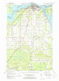
1951 Map of Sault Ste. Marie
USGS Topo · Published 1958About this map
The Sault Ste. Marie waterfront and the iconic Soo Locks dominate this mid-century portrait of the international border. Along the Saint Marys River, the map captures a transition between the industrial navigation channels of the Little Rapids Channel and the rural reaches of Sugar Island. The transport network is particularly dense here, featuring the Minneapolis St Paul and Sault Ste Marie RR and the Duluth South Shore and Atlantic RR converging on the city. Further south, the landscape shifts toward the massive Munuscong State Forest and agricultural settlements like Dafter and Donaldson. Notable for genealogists are the numerous rural schoolhouses, such as Christie Sch and McKinnon Sch, alongside military installations including Camp Lucas and the northern edge of the Kinross Air Force Base.
Find a feature on this map
60 named features on this map. Tap any name to fly to it.
Don’t see what you’re looking for? This feature index may not catch every label — zoom into the map to look around manually.
Map Details
Editions of this 1951 Sault Ste. Marie Map
2 editions found
Other maps of this area

1913 · Sault Sainte Marie
USGS Topo · 1:62,500

1919 · Neebish
USGS Topo · 1:62,500

1941 · Neebish
USGS Topo · 1:63,360

1941 · Sault Sainte Marie
USGS Topo · 1:63,360

1941 · Brimley
USGS Topo · 1:63,360

1951 · Shallows
USGS Topo · 1:24,000

1951 · Kinross
USGS Topo · 1:24,000

1951 · Dafter
USGS Topo · 1:24,000

1951 · Barbeau
USGS Topo · 1:24,000

1951 · Baie De Wasai
USGS Topo · 1:24,000