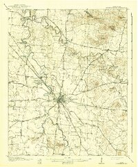
1916 Map of Murfreesboro
USGS Topo · Published 1941About this map
Murfreesboro sits at the heart of this mid-1910s landscape, serving as a hub for a radiating network of turnpikes including the Nashville Turnpike and Shelbyville Turnpike. The surrounding Rutherford County countryside is marked by numerous crossroads settlements like Walter Hill, Lascassas, and Salem, each supported by local institutions such as Silver Hill School and Jordan School. Along the West Fork of the Stone River, the Stones River National Military Park and the Stones River National Cemetery preserve the memory of the Civil War battlefield, located near the Nashville Chattanooga and St Louis RR tracks. The map records a transition from river-dependent industry, evidenced by Wards Mill and Browns Mill, to an era of expanded road connectivity. Prominent terrain features like Grandfather Knob and the Marshall Knobs rise above the river valleys, while natural water sources such as Fox Camp Spring and Sulphur Spring punctuate the limestone-rich topography of Middle Tennessee.
Find a feature on this map
74 named features on this map. Tap any name to fly to it.
Don’t see what you’re looking for? This feature index may not catch every label — zoom into the map to look around manually.
Map Details
Editions of this 1916 Murfreesboro Map
2 editions found
Other maps of this area

1903 · Nashville
USGS Topo · 1:125,000

1908 · Woodbury
USGS Topo · 1:62,500

1913 · Hollow Springs
USGS Topo · 1:62,500

1916 · Murfreesboro
USGS Topo · 1:62,500

1932 · Hermitage
USGS Topo · 1:62,500

1936 · Webbs Jungle
USGS Topo · 1:24,000

1936 · Rover
USGS Topo · 1:24,000

1936 · Beech Grove
USGS Topo · 1:24,000

1936 · Fosterville
USGS Topo · 1:24,000

1942 · Statesville
USGS Topo · 1:100,000