1934 Map of Murphy
USGS Topo · Published 1934About this map
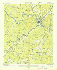
The confluence of the Hiwassee River and the Nottely River anchors this 1934 Tennessee Valley Authority study of western North Carolina. As the regional hub, Murphy is shown at a critical transition point where the Louisville and Nashville RR and Southern Ry meet, supporting a local economy built on mining and river transport. A notable Talc Mine sits near Kinsey, illustrating the industrial activity alongside traditional rural landmarks like Rogers Chapel and Bates Sch. The map reveals a landscape before major hydroelectric changes, marking the positions of Mill Dam and Nottely Dam. From the heights of Fort Butler Mtn to the small community at Regal Station, this survey documents the Cherokee County terrain during a period of significant infrastructure development by the TVA.
Find a feature on this map
116 named features on this map. Tap any name to fly to it.
Don’t see what you’re looking for? This feature index may not catch every label — zoom into the map to look around manually.
Map Details
Editions of this 1934 Murphy Map
This is the sole edition of this map. No revisions or reprints were ever made.
Other maps of this area

1886 · Dahlonega
USGS Topo · 1:125,000

1888 · Ellijay
USGS Topo · 1:125,000

1892 · Dahlonega
USGS Topo · 1:125,000

1892 · Ellijay
USGS Topo · 1:125,000

1893 · Murphy
USGS Topo · 1:125,000

1896 · Dahlonega
USGS Topo · 1:125,000

1898 · Ellijay
USGS Topo · 1:125,000

1903 · Dahlonega
USGS Topo · 1:125,000

1911 · Ellijay
USGS Topo · 1:125,000

1914 · Murphy
USGS Topo · 1:125,000