1934 Map of Murphy
USGS Topo · Published 1934About this map
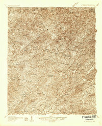
Murphy serves as the focal point of this 1930s survey, situated at the confluence of the Hiwassee River and the Valley River. The landscape is marked by the complex topography of the Cherokee National Forest and the Indian Land (Henson Donation). Industrial and transit history is preserved through the Culberson Mine and the intersection of the Southern and Louisville and Nashville railroads, with Regal Sta serving the outlying areas.
Find a feature on this map
57 named features on this map. Tap any name to fly to it.
Don’t see what you’re looking for? This feature index may not catch every label — zoom into the map to look around manually.
Map Details
Editions of this 1934 Murphy Map
This is the sole edition of this map. No revisions or reprints were ever made.
Other maps of this area

1886 · Dahlonega
USGS Topo · 1:125,000

1888 · Ellijay
USGS Topo · 1:125,000

1892 · Dahlonega
USGS Topo · 1:125,000

1892 · Ellijay
USGS Topo · 1:125,000

1893 · Murphy
USGS Topo · 1:125,000

1896 · Dahlonega
USGS Topo · 1:125,000

1898 · Ellijay
USGS Topo · 1:125,000

1903 · Dahlonega
USGS Topo · 1:125,000

1911 · Ellijay
USGS Topo · 1:125,000

1914 · Murphy
USGS Topo · 1:125,000