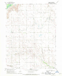
1969 Map of Murphy
USGS Topo · Published 1971About this map
Agricultural life in Hamilton County is defined by the convergence of several major waterways and the reliable presence of the Chicago Burlington and Quincy railroad. The landscape is marked by the expansive Platte River in the northwest and the winding courses of the Big Blue River and Lincoln Creek further south. This period reveals a rural infrastructure built on irrigation, with numerous groundwater wells distributed across the townships of Monroe, South Platte, and Grant. Small aviation facilities like the Hanson Landing Strip and Luthy Landing Strip serve the local farming community near the settlement of Murphy. Local heritage is anchored by sites such as Monroe Ch, Siloa Cem, and Richland Cem, which provide essential points of reference for genealogical research in this Nebraska heartland.
Find a feature on this map
17 named features on this map. Tap any name to fly to it.
Don’t see what you’re looking for? This feature index may not catch every label — zoom into the map to look around manually.
Map Details
Editions of this 1969 Murphy Map
This is the sole edition of this map. No revisions or reprints were ever made.
Other maps of this area

1896 · Stromsburg
USGS Topo · 1:125,000

1898 · York
USGS Topo · 1:125,000

1898 · Grand Island
USGS Topo · 1:125,000

1899 · St. Paul
USGS Topo · 1:125,000

1899 · York
USGS Topo · 1:125,000

1955 · Broken Bow
USGS Topo · 1:250,000

1955 · Fremont
USGS Topo · 1:250,000

1955 · Lincoln
USGS Topo · 1:250,000

1955 · Grand Island
USGS Topo · 1:250,000

1956 · Broken Bow
USGS Topo · 1:250,000