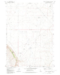
1979 Map of Murphy Hot Springs
USGS Topo · Published 1980About this map
Murphy Hot Springs sits at the edge of the East Fork Jarbidge River on this 1970s survey, marking a distinct pocket of settlement at the base of steep canyon walls. The surrounding landscape transitions sharply from the deep river valley to the broad, arid stretches of the Inside Desert and Big Flat. This transition illustrates the remote ranching and recreation infrastructure of the high desert, where water management is critical to the local economy. The map documents several man-made water features including the Poison Creek Reservoir, Jim Bob Reservoir, and the CCC Rock Pond, along with supporting aviation access via the Murphy Hot Springs Air Strip. Named high points like Pence Butte and Horse Hill dominate the eastern horizon, while a network of jeep trails and the Clover Three Creek Road provide the only passage through this frontier terrain along the Idaho-Nevada border.
Find a feature on this map
23 named features on this map. Tap any name to fly to it.
Don’t see what you’re looking for? This feature index may not catch every label — zoom into the map to look around manually.
Map Details
Editions of this 1979 Murphy Hot Springs Map
This is the sole edition of this map. No revisions or reprints were ever made.
Other maps of this area

1943 · Jarbidge
USGS Topo · 1:62,500

1945 · Jarbidge
USGS Topo · 1:62,500

1955 · Twin Falls
USGS Topo · 1:250,000

1955 · Wells
USGS Topo · 1:250,000

1957 · Elk Mountain
USGS Topo · 1:62,500

1958 · Wells
USGS Topo · 1:250,000

1958 · Twin Falls
USGS Topo · 1:250,000

1961 · Wells
USGS Topo · 1:250,000
1979 · Dishpan
USGS Topo · 1:24,000

1979 · Salls Crossing
USGS Topo · 1:24,000