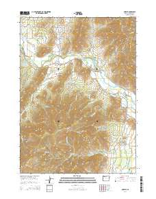
2014 Map of Murphy
USGS Topo · Published 2014About this map
The Murphy community and neighboring New Hope anchor this 2014 survey of Josephine County, where the Applegate River carves through the landscape. The river valley is a hub of hydraulic management, evidenced by the intricate Murphy Ditch and several water storage sites including Spalding Reservoir and Reinhardt Reservoir. This modern map shows a high density of residential development along the Williams Hwy corridor, contrasted with the steeper terrain of the surrounding hills. Prominent landmarks such as Pennington Butte and Pickett Mtn define the local topography, while numerous gulches like Schoolhouse Gulch and Wildcat Gulch indicate the drainage patterns feeding into the Applegate. Further south, the map details the more secluded environs of Pennington Cr and Powell Cr, including the specialized Lippert Reservoir Number Two and Webb Reservoir.
Find a feature on this map
90 named features on this map. Tap any name to fly to it.
Don’t see what you’re looking for? This feature index may not catch every label — zoom into the map to look around manually.
Map Details
Editions of this 2014 Murphy Map
This is the sole edition of this map. No revisions or reprints were ever made.
Other maps of this area

1908 · Grants Pass
USGS Topo · 1:125,000

1954 · Oregon Caves
USGS Topo · 1:62,500

1954 · Gold Hill
USGS Topo · 1:62,500

1954 · Grants Pass
USGS Topo · 1:62,500

1954 · Ruch
USGS Topo · 1:62,500

1955 · Medford
USGS Topo · 1:250,000

1957 · Medford
USGS Topo · 1:250,000

1958 · Medford
USGS Topo · 1:250,000

1974 · Grants Pass NW
USGS Topo · 1:24,000
1974 · Grants Pass NE
USGS Topo · 1:24,000