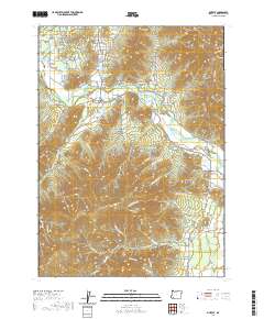
2020 Map of Murphy
USGS Topo · Published 2020About this map
The Applegate River flows through this southwestern Oregon landscape, defining a valley where the settlement of Murphy and its associated Murphy-Bridge serve as central landmarks. Water management is a primary feature of the local geography, evidenced by an extensive network of irrigation and storage including the Murphy-Ditch and numerous small impoundments like Lincoln-Savage Reservoir, Fifer Reservoir, and Tobiason Reservoir. The surrounding hills are marked by localized place names such as Schoolhouse Gulch, Packers Gulch, and Wildcat Gulch, reflecting the rugged character of the terrain between the valley floor and heights like Pennington Butte.
Find a feature on this map
95 named features on this map. Tap any name to fly to it.
Don’t see what you’re looking for? This feature index may not catch every label — zoom into the map to look around manually.
Map Details
Editions of this 2020 Murphy Map
This is the sole edition of this map. No revisions or reprints were ever made.
Other maps of this area

1908 · Grants Pass
USGS Topo · 1:125,000

1954 · Oregon Caves
USGS Topo · 1:62,500

1954 · Gold Hill
USGS Topo · 1:62,500

1954 · Grants Pass
USGS Topo · 1:62,500

1954 · Ruch
USGS Topo · 1:62,500

1955 · Medford
USGS Topo · 1:250,000

1957 · Medford
USGS Topo · 1:250,000

1958 · Medford
USGS Topo · 1:250,000

1974 · Grants Pass NW
USGS Topo · 1:24,000
1974 · Grants Pass NE
USGS Topo · 1:24,000