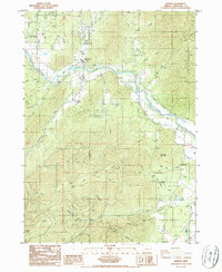
1986 Map of Murphy
USGS Topo · Published 1986About this map
The Applegate River defines the central corridor of this mid-1980s landscape, where the settlements of Murphy and New Hope sit at the intersection of river-valley agriculture and high-timber ridges. This era captures the region's long-standing connection to resource extraction, evidenced by several prominent workings in the southern hills. While commercial Gravel Pit operations are found near the river, the deeper terrain is marked by hard-rock sites such as the Oregon Bonanza Mine, the Humdinger Mine, and the Snow Bird Mine. The map reveals a complex drainage network feeding into the Applegate, including Onion Creek and Wildcat Gulch to the north, and Powell Creek and Horsehead Creek to the south. These waterways carve through notable heights like Pennington Mountain and Mungers Butte, where Iron Mountain Road and numerous tracks provide access to remote Mine Shafts and prospect sites.
Find a feature on this map
34 named features on this map. Tap any name to fly to it.
Don’t see what you’re looking for? This feature index may not catch every label — zoom into the map to look around manually.
Map Details
Editions of this 1986 Murphy Map
This is the sole edition of this map. No revisions or reprints were ever made.
Other maps of this area

1908 · Grants Pass
USGS Topo · 1:125,000

1954 · Oregon Caves
USGS Topo · 1:62,500

1954 · Gold Hill
USGS Topo · 1:62,500

1954 · Grants Pass
USGS Topo · 1:62,500

1954 · Ruch
USGS Topo · 1:62,500

1955 · Medford
USGS Topo · 1:250,000

1957 · Medford
USGS Topo · 1:250,000

1958 · Medford
USGS Topo · 1:250,000

1974 · Grants Pass NW
USGS Topo · 1:24,000
1974 · Grants Pass NE
USGS Topo · 1:24,000