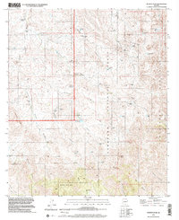
1996 Map of Murphy Peak
USGS Topo · Published 2002About this map
Murphy Peak and the surrounding high desert of the Tumacacori Mountains define this landscape, where cattle ranching and water management shape the terrain. A complex network of livestock infrastructure is evident through numerous named water sources like Lower Sardina Well, Cedar Windmill, and Bear Grass Tank, illustrating the vital importance of water rights in this arid borderland region. Much of the eastern portion lies within the Coronado National Forest, showing a transition from the drainage of Moyza Canyon and Cedar Canyon toward the high summits.
Find a feature on this map
62 named features on this map. Tap any name to fly to it.
Don’t see what you’re looking for? This feature index may not catch every label — zoom into the map to look around manually.
Map Details
Editions of this 1996 Murphy Peak Map
This is the sole edition of this map. No revisions or reprints were ever made.
Other maps of this area

1920 · Arivaca
USGS Topo · 1:125,000

1921 · Old Glory
USGS Topo · 1:125,000

1939 · Tubac
USGS Topo · 1:62,500

1941 · Arivaca
USGS Topo · 1:62,500

1942 · Ruby
USGS Topo · 1:62,500

1942 · Oro Blanco
USGS Topo · 1:62,500

1943 · Arivaca
USGS Topo · 1:62,500

1943 · Old Glory
USGS Topo · 1:125,000

1943 · Tubac
USGS Topo · 1:62,500

1944 · Oro Blanco
USGS Topo · 1:62,500