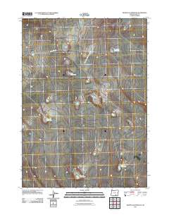
2011 Map of Murphy Waterholes
USGS Topo · Published 2011About this map
Murphy Waterholes define this high desert reach of Lake County, where water sources are the primary landmarks in an otherwise sparse landscape. This 2011 survey illustrates the critical role of these catchment points for livestock and wildlife management, with named sites such as Zero Waterhole, Westside Waterhole, and Socket Waterhole distributed across the terrain. Human activity is evidenced by the Murphy Corral and the thin line of Pistol Spring Rd, which passes near the ephemeral Pistol Lake. The nomenclature on this sheet suggests a legacy of ranching and range management, where even small features like the Cox Butte Waterhole and Murphy Waterhole are vital enough to be named on official topographic records.
Find a feature on this map
9 named features on this map. Tap any name to fly to it.
Don’t see what you’re looking for? This feature index may not catch every label — zoom into the map to look around manually.
Map Details
Editions of this 2011 Murphy Waterholes Map
This is the sole edition of this map. No revisions or reprints were ever made.
Other maps of this area

1955 · Adel
USGS Topo · 1:250,000

1957 · Adel
USGS Topo · 1:250,000

1958 · Adel
USGS Topo · 1:250,000

1962 · Adel
USGS Topo · 1:250,000

1966 · Bluejoint Lake East
USGS Topo · 1:24,000

1967 · Flook Lake
USGS Topo · 1:24,000

1967 · Swede Knoll
USGS Topo · 1:24,000

1971 · Beatys Butte
USGS Topo · 1:24,000

1971 · Murphy Waterholes
USGS Topo · 1:24,000
1971 · Sixmile Draw
USGS Topo · 1:24,000