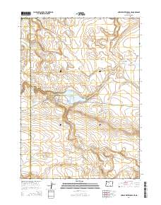
2014 Map of Murphy Waterholes NE
USGS Topo · Published 2014About this map
Rock Cr Reservoir serves as a central hydrological landmark in this high-desert region of the Great Basin, where the management of scarce water resources defines the land use. Situated at the western edge of the expansive Catlow Valley, the terrain is marked by the sharp incision of Buckhorn Canyon and the seasonal flow of Rock Cr. The map documents the remote infrastructure of Harney County, including the Oreana Waterhole, which highlights the historical and ongoing importance of specific water points for livestock and wildlife in this arid environment. The road network is sparse, centered on Frenchglen Rd and Rock Creek Ln, tracing the paths that connect these isolated water sources across the township lines of the Oregon desert.
Find a feature on this map
14 named features on this map. Tap any name to fly to it.
Don’t see what you’re looking for? This feature index may not catch every label — zoom into the map to look around manually.
Map Details
Editions of this 2014 Murphy Waterholes NE Map
This is the sole edition of this map. No revisions or reprints were ever made.
Other maps of this area

1955 · Adel
USGS Topo · 1:250,000

1957 · Adel
USGS Topo · 1:250,000

1958 · Adel
USGS Topo · 1:250,000

1962 · Adel
USGS Topo · 1:250,000

1971 · Duhaime Flat East
USGS Topo · 1:24,000

1971 · Murphy Waterholes
USGS Topo · 1:24,000

1971 · Orejana Canyon
USGS Topo · 1:24,000
1971 · Sixmile Draw
USGS Topo · 1:24,000
1971 · Guano Reservoir
USGS Topo · 1:24,000
1971 · Duhaime Flat West
USGS Topo · 1:24,000