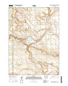
2017 Map of Murphy Waterholes NE
USGS Topo · Published 2017About this map
Rock Cr Reservoir serves as a central hydrological point in this high-desert region of Harney County, where water management is vital to the local landscape. The map details the transition from the wide floor of Catlow Valley into more varied terrain defined by features like Buckhorn Canyon. This 2017 survey reflects the enduring character of the Oregon outback, where life and transit are dictated by the presence of intermittent water sources such as Oreana Waterhole.
Find a feature on this map
13 named features on this map. Tap any name to fly to it.
Don’t see what you’re looking for? This feature index may not catch every label — zoom into the map to look around manually.
Map Details
Editions of this 2017 Murphy Waterholes NE Map
This is the sole edition of this map. No revisions or reprints were ever made.
Other maps of this area

1955 · Adel
USGS Topo · 1:250,000

1957 · Adel
USGS Topo · 1:250,000

1958 · Adel
USGS Topo · 1:250,000

1962 · Adel
USGS Topo · 1:250,000

1971 · Duhaime Flat East
USGS Topo · 1:24,000

1971 · Murphy Waterholes
USGS Topo · 1:24,000

1971 · Orejana Canyon
USGS Topo · 1:24,000
1971 · Sixmile Draw
USGS Topo · 1:24,000
1971 · Guano Reservoir
USGS Topo · 1:24,000
1971 · Duhaime Flat West
USGS Topo · 1:24,000