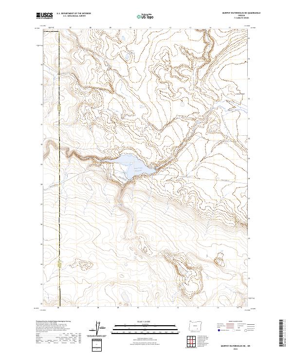
2024 Map of Murphy Waterholes NE
USGS Topo · Published 2024About this map
Hart Mountain National Antelope Refuge occupies the western edge of this map, marking a transition between the high desert plateaus and the lower basin of the Catlow Valley. The landscape is defined by its vital water sources, most notably the Rock Creek Reservoir which captures the flow of Rock Creek as it descends through the local topography. This area of Harney County reveals a sparse but deliberate network of infrastructure, where Frenchglen Rd and Rock Creek Ln provide the primary access to this isolated terrain. Further north, Buckhorn Canyon cuts through the high ground, and the Oreana Waterhole stands as a discrete landmark in the northern range, illustrating the critical importance of specific water points in this arid region of southeastern Oregon.
Find a feature on this map
14 named features on this map. Tap any name to fly to it.
Don’t see what you’re looking for? This feature index may not catch every label — zoom into the map to look around manually.
Map Details
Editions of this 2024 Murphy Waterholes NE Map
This is the sole edition of this map. No revisions or reprints were ever made.
Other maps of this area

1955 · Adel
USGS Topo · 1:250,000

1957 · Adel
USGS Topo · 1:250,000

1958 · Adel
USGS Topo · 1:250,000

1962 · Adel
USGS Topo · 1:250,000

1971 · Duhaime Flat East
USGS Topo · 1:24,000

1971 · Murphy Waterholes
USGS Topo · 1:24,000

1971 · Orejana Canyon
USGS Topo · 1:24,000
1971 · Sixmile Draw
USGS Topo · 1:24,000
1971 · Guano Reservoir
USGS Topo · 1:24,000
1971 · Duhaime Flat West
USGS Topo · 1:24,000