
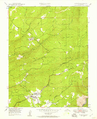
1948 Map of Murphys
USGS Topo · Published 1979About this map
The gold-bearing foothills of Calaveras County are documented here in the late 1940s, centered on the community of Murphys and its proximity to notable mineral and natural landmarks. The terrain is marked by deep gulches and the prominent Table Mountain to the south, while the Stanislaus National Forest defines the eastern boundary. This era shows the active intersection of early industry and local healthcare, exemplified by the Bret Harte Sanatorium located just north of town and the Utica Powerhouse along Angels Creek.
Find a feature on this map
43 named features on this map. Tap any name to fly to it.
Don’t see what you’re looking for? This feature index may not catch every label — zoom into the map to look around manually.
Map Details
Editions of this 1948 Murphys Map
Other maps of this area

1889 · Jackson
USGS Topo · 1:125,000

1891 · Big Trees
USGS Topo · 1:125,000

1892 · Jackson
USGS Topo · 1:125,000

1894 · Big Trees
USGS Topo · 1:125,000

1897 · Jackson
USGS Topo · 1:125,000

1897 · Big Trees
USGS Topo · 1:125,000

1901 · Big Trees
USGS Topo · 1:125,000

1902 · Jackson
USGS Topo · 1:125,000
1945 · San Andreas
USGS Topo · 1:62,500
1947 · San Andreas
USGS Topo · 1:62,500